Chief Joseph Highway and Beartooth Highway. Pictures are in reverse order of travel, but are in sequence, so this is my trip driving in reverse.
The Beartooth Highway has been called the "Most Beautiful Drive in America" by Charles Kuralt. I'm not sure "most beautiful", but it is up there and it is spectacular. It is US 212 and goes from Red Lodge, MT to Silver Gate (or Cooke City) to the west. . Wyoming 296 is the Chief Joseph Highway and starts 17 miles north of Cody and meets up with the Beartooth about seventeen miles from Cooke City. (The time and distance box is over the Chief Joseph Highway.)
I drove the loop clockwise, but the pictures loaded up backward, so I'll start just to the east of Red Lodge. This is the back of the mountain that the Beartooth highway goes over. It doesn't look that formidable. The drive starts in Red Lodge, MT at an elevation of 5568 ft.
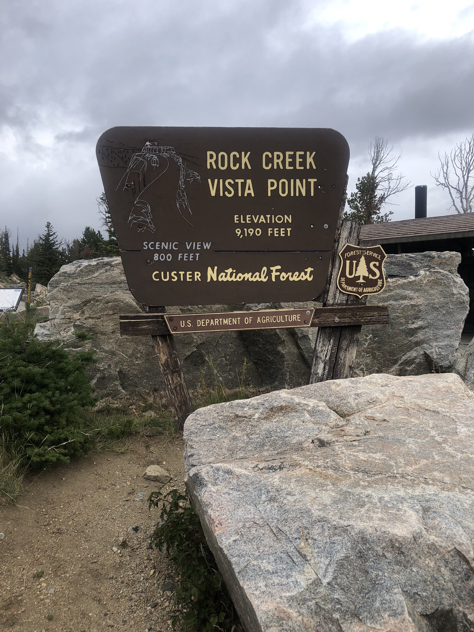
This is at Vista Point. It is about 2/3 of the way up the mountain at an elevation of 9190 ft.
This is looking to the north where the road starts. This is looking south showing some of the switchbacks.
My students would know this is an infinite slope Bent trees like this are a positive sign of slope failure and the angle of repose is equal to Φ. movement.
A little further up showing some of the switchbacks.
This is supposed to be the highest state sign in the US. Note it is covered with various stickers.
The top of Beartooth Pass, elevation 10947 ft. The instrument panel shows that is 34 degrees and the windshield shows that it is sleeting.
Driving into the clouds. (I wasn't really driving. I stopped and took the picture.)
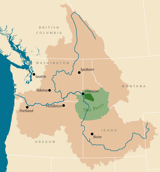
You cannot be in this part of the country without encountering the historic flight of a band of "non-treaty" Nez Perce Indians trying to escape being rounded up and sent to their reservation, an area approximately 1/50th of their traditional hunting and fishing area in parts of Washington, Oregon, Idaho, Montana and Wyoming. The Treaty of 1855 created the reservation shown in light green. The discovery of gold in 1860 forced a new Treaty of 1866 which reduced the reservation to the area in dark green, 1200 square miles. A significant number of the tribe, approximately 1000 people, did not accept the treaties and were known as the "non-treaty" indians. In attempting to force this group into the reservation, a war broke out in 1877. General Howard had a command of 5,000 men and started chasing this band from the reservation to the east. 
The tribe took the general route shown in red below while Howard's route is the black dashed line. Chief Joseph and several sub-chiefs were able to evade the US troops for months, starting in June, 1877. By the time the Nez Perce got to Yellowstone country and east (where I'm traveling now) it was into September. They numbered about 800 people at this time and 3,000 horses.
When they got to the area around what is now Yellowstone Lake, the chiefs split the band up and went in several different directions around the area where the Chief Joseph Highway is located now. This action confused Howard and he lost the trail altogether, going too far north. When the different bands regathered, they started to head north to Canada to meet up with Sitting Bull located just north of the border. The details become really complicated, with at least five other companies of troops joining the chase. Finally, the band got to within 30 miles of the Canadian border when they became trapped and captured. This is where Chief Joseph said the famous words, "I will fight no more forever." During the campaign, approximately 260 Nez Perce men, women and children died, and over 250 soldiers.
In the capture negotiations, they were promised they would be returned to the reservation in Idaho. Instead, they were taken to a reservation in Oklahoma. (There are many different details of this story on-line, numbers, directions, even times, but this is the general story. I'll pick up more a couple of pictures down.)

I continued on the Beartooth to Cooke City and to the Northeast Park entrance. It was closed, which I knew. It has been closed since the flooding in June
Cooke City was a mining town with gold and other minerals found there in the 1890s. Talking to an old timer at the museum, their busy season is June-July and Feb-Mar. Great snowmobiling into the park in the early spring.
A sign as you enter or leave town. I thought it was ironic with the bare hillside behind it.
Right before you get to the entrance, there was this little BBQ stand. I got pumped for some Q, but when I drove up, I read the sign next to the order window...... heck....
There was this cabin on the outskirts of town. I had to read the sign. Someone has a sense of humor.

The Chief Joseph Highway
The Chief Joseph Highway joins the Beartooth Highway about 17 miles east of Cooke City between Crazy Creek and Lake Creek. It was conceived to be a second entrance into Yellowstone Park from Cody. The map below shows the western portion of the highway.
The yellow dashed line is the likely path of Nez Perce Indians through this section. The records of the time are not exact, but this is the most probable path.
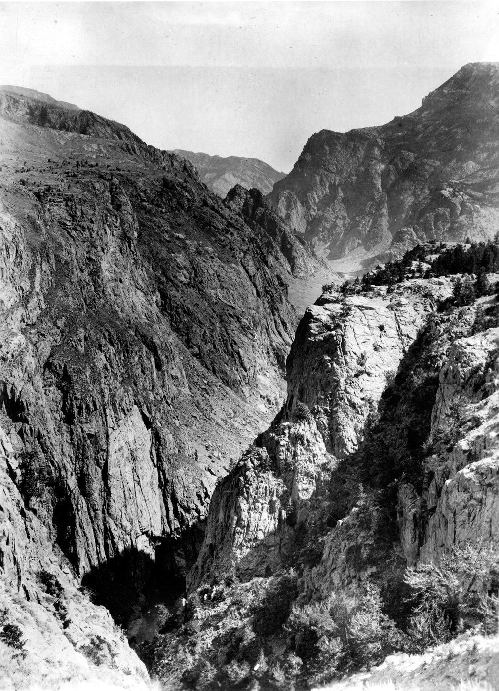
The western part of the highway parallels the Clark's Fork of the Yellowstone River. At over 1,200 feet, this is the third deepest canyon in the lower United States. It is known for its fishing and kayaking. It can be very dangerous kayaking with continuous Class IV-VI rapids, waterfalls and drops. The photo is from the 1893 US Geological Survey. Unfortunately, you can't see it from the road, but apparently there are short walks to some lookouts. I missed them.
Note that the Nez Perce stayed on the south rim of the canyon, right where the road is located.
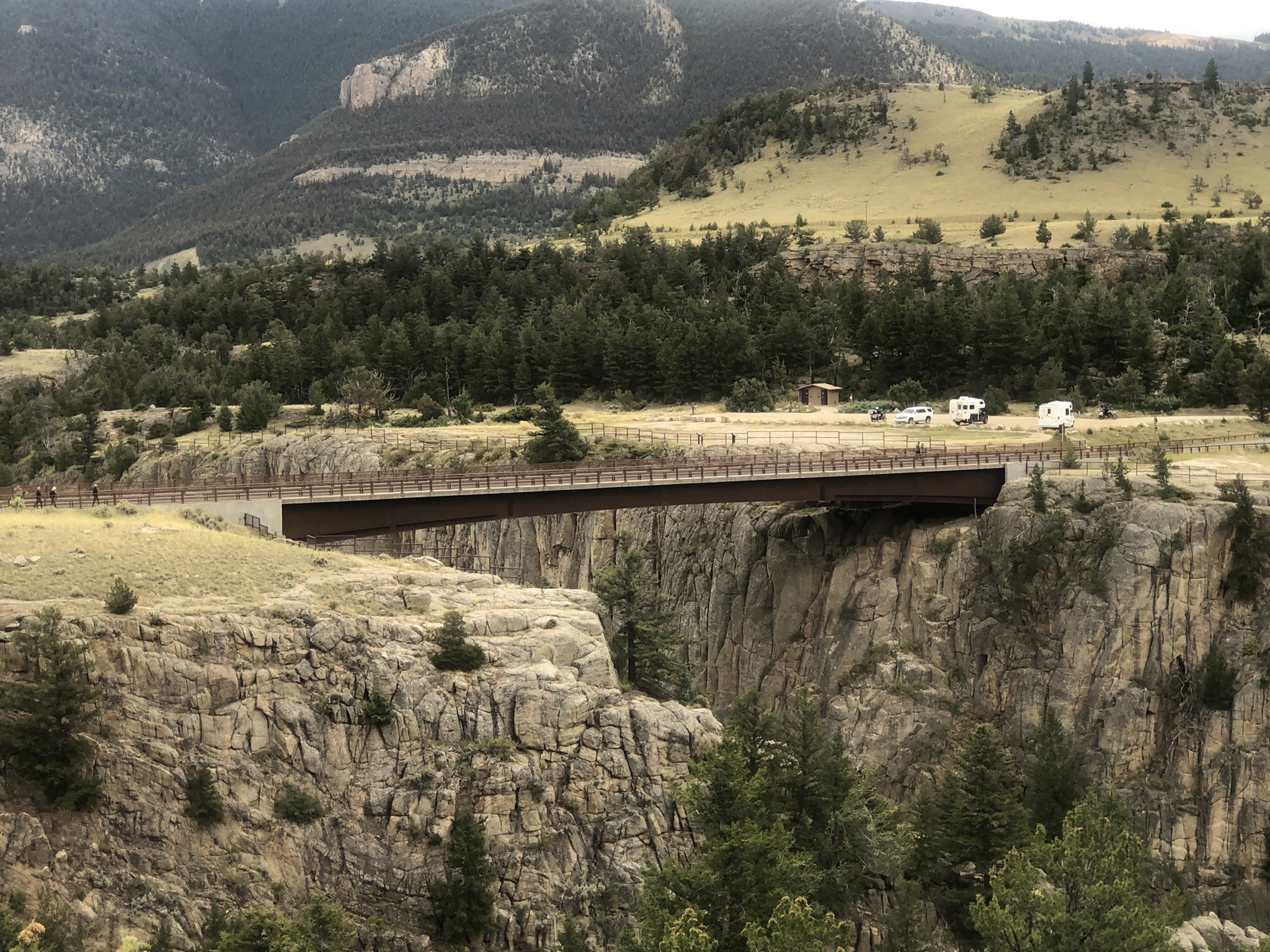
The next section of the road crosses over the Sunlight Bridge over Sunlight valley and canyon.~2.jpeg)
The bridge is really striking and has won a number of awards for the Wyoming Department of Transportation (and for the contractor). There is a YouTube video that really gives it some perspective. For an engineer, it is a beauty in its complex simplicity. (There is a lot of calculus in that curved simple span beam,) BTW, one of the blogs I read says it is a concrete bridge. Wrongo. It is a steel bridge with a concrete deck.
Not being able to cross this canyon, the Nez Perce headed south where it was possible to cross the creek. They passed over the next ridge into the Dead Indian Creek and apparently followed it down to the lower Clark's Fork and out into the plains. While most of the Nez Perce group passed this area along what is now called Dead Indian Creek, a few small groups went in different directions to act as decoys. One group went up and crossed the mountains on the Dead Indian Trail. A sign at the top of the pass has this written on it.
Thus the name Dead Indian for the creek, the mountain pass and the campground where the road crosses the creek. While no longer politically correct, it is the name on the USGS topo maps.
The road follows the creek for a while (the longest straight section below), the road starts climbing the western face for Dead Indian Mountain. It snakes back and forth up to the pass (at the triangle).
When you finally get back to the main Highway 120 between Cody and Billings, MT, you turn right to head south to Cody. The mountain on your left is Heart Mountain. Look back as you drive into Cody and you'll see the head of a person on the left and the bulging heart on the chest.
This isn't the view of Heart Mountain that most people know. On the eastern flank of the mountain, the US government set up the Heart Mountain Relocation Center, a Japanese-American incarceration camp during World War II. This is the view of Heart Mountain from the internment camp (1943). To Close Two Circles:
1) Pete and Alan Simpson were 13 and 12 year old Boy Scouts in Cody, WY during the war. They attended a Jamboree inside the camp where they met fellow Boy Scout Norman Mineta. Alan and Norman later became US Senator, and US Secretary of Transportation and Secretary of Commerce, respectively. There is now a foundation at Heart Mountain named after them.


~2.jpeg)


Comments
Post a Comment